Gallery containing mountains and scenery (public domain) photos from the Canadian National Parks – Western Canada. The vast majority of mountains in Canada lie in the western provinces of British Columbia and Alberta and the Yukon Territory. Mountains can be found all over British Columbia while those in Alberta are mainly concentrated on the eastern side of the Canadian Rockies.


The South Saskatchewan River is a major river in Canada that flows through the provinces of Alberta and Saskatchewan. For the first half of the 20th century, the South Saskatchewan would completely freeze over during winter, creating spectacular ice breaks and dangerous conditions in Saskatoon, Medicine Hat and elsewhere. At least one bridge in Saskatoon was destroyed by ice carried by the river. The river originates at the confluence of the Bow and Oldman Rivers near Grassy Lake, Alberta. The waters of these two rivers, in turn, originate from glaciers in the Rocky Mountains near the British Columbia border.
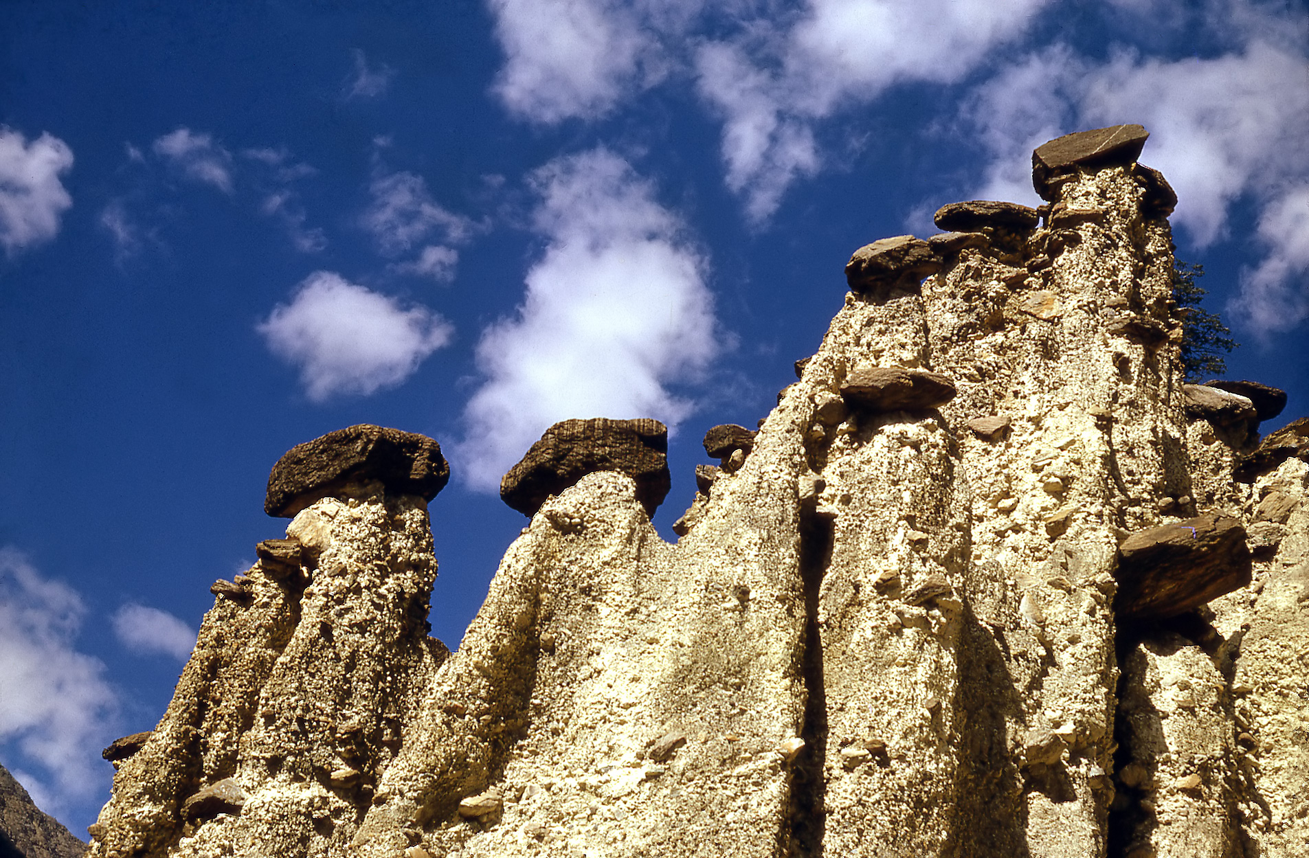
A hoodoo (also called a tent rock, fairy chimney, and earth pyramid) is a tall, thin spire of rock that protrudes from the bottom of an arid drainage basin or badland. Hoodoos, which can range from 5-150 feet tall (1.5-45 meters), typically consist of relatively soft rock topped by harder, less easily eroded stone that protects each column from the elements. They generally form within sedimentary rock and volcanic rock formations.


Natural bridges, also called natural archs, are naturally created formations resembling a bridge. Most natural bridges are erosion features that occur in massive, horizontally bedded sandstone or limestone. Some bridges are formed by the collapse of a cavern’s roof that may leave remnant portions as bridges. Others may be produced by entrenched rivers eroding through meander necks to form cutoffs. Still others are produced by exfoliation and may be enlarged by wind erosion.
Kootenay Lake is a lake located in British Columbia, Canada and is part of the Kootenay River. The lake has been raised by the Corra Linn Dam and has a dike system at the southern end, which, along with industry in the 1950s- 70s, has changed the ecosystem in and around the water. It is one of the largest lakes in British Columbia, at 104 km in length and 3-5 km in width. It is, in part, a widening of the Kootenay River, which in turn drains into the Columbia River system at Castlegar, British Columbia.
Kootenay Lake is part of the traditional territory of the Sinixt and Ktunaxa peoples. These native populations used the lake and associated river systems as part of their seasonal migration and trading routes. The lake originally tidally and seasonally flooded an approximately 80 km long marsh lying to the lake’s south within the Creston Valley. However, this has now been diked and converted to commercial agriculture. A smaller wetland area has been protected in this area.


Lake O’Hara is a lake at an elevation of 2,115 m in the alpine area of Yoho National Park, in the province of British Columbia, on the western side of the Great Divide with the province of Alberta and Banff National Park to the east. The lake and the valley are accessible through a bus service that is run by Parks Canada or by a 11 km hike along a road with an elevation gain of approximately 500m. The area is known for its scenery as well as its alpine hiking. The number of people who access the area has been limited in order to preserve the sensitive alpine environment.
Larches are conifers in the genus Larix, in the family Pinaceae. Growing from 20 to 45 m tall, they are native to much of the cooler temperate northern hemisphere, on lowlands in the north and high on mountains further south. Larch are among the dominant plants in the immense boreal forests of Russia and Canada. Although a conifer, the larch is a deciduous tree and loses its leaves in the autumn.